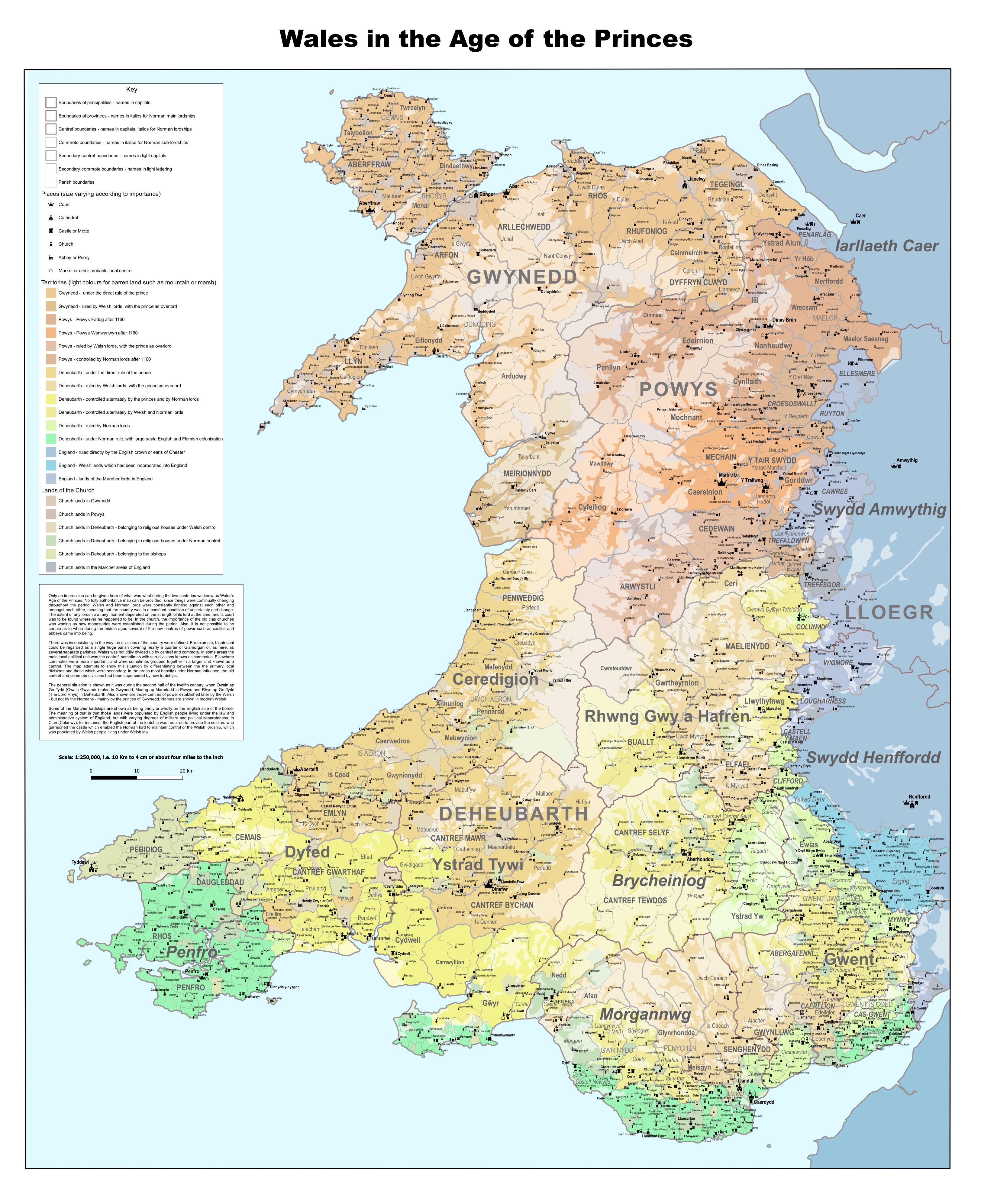
The Ancient Divisions of the Country
The initial intention in creating this map was to attempt to show the location and borders of the old cantref and commote divisions of Wales, before it became evident that it was not entirely possible to do so. Wales was not tidily divided up by cantref and commote. In some areas the main local political unit was the cantref, sometimes with sub-divisions known as commotes. Elsewhere commotes were more important and were sometimes grouped together in a larger unit known as a cantref. In some areas the old cantref and commote divisions were forgotten, having been superseded by new lordships following the advent of Anglo-Norman domination.
What this map therefore attempts to show is how the Welsh people saw and understood where was where and what was what in their country in the earliest period when that is possible, following the initial coming of the Normans but after they had been largely pushed back by the resistance of the Welsh princes. The general situation is shown as it was during the second half of the twelfth century, when Owain ap Gruffydd (Owain Gwynedd) ruled in Gwynedd, Madog ap Maredudd in Powys and Rhys ap Gruffydd (The Lord Rhys) in Deheubarth. Also shown are those centres of power established later by the Welsh – but not by the Normans – mainly by the princes of Gwynedd.
Most of the information used in compiling the map comes from a later period, following the victory of the king of England towards the end of the thirteenth century. However, it was thought that there was sufficient evidence to attempt to show the situation during the preceding two centuries, the period known as the Age of the Princes.
Only an impression can be given here of what was what during that period. No fully authoritative map can be provided, since things were continually changing throughout the period. Welsh and Norman lords were constantly fighting against each other and amongst each other, meaning that the country was in a constant condition of uncertainty and change. The extent of any lordship at any moment depended on the strength of its lord at the time, and its court was to be found wherever he happened to be. In the church, the importance of the old clas churches was waning as new monasteries were established during the period. Also, it is not possible to be certain as to when during the middle ages several of the new centres of power such as castles and abbeys came into being. So many of the details shown could be subject to argument, but it must be accepted that it is only possible to present a general picture.
It would be wrong to think of the kingdoms, cantrefi and commotes shown on the map as ancient and immutable entities. Gwynedd was quite a stable realm – with changeable boundaries – and had been for several hundred years, but the other Welsh realms had a history of coming and going. Gwynedd was conquered early by the Normans, but they were soon expelled by Gruffydd ap Cynan. Even there were signs of recent restructuring following the short-lived period of Norman domination. For instance, in Llŷn it may well be that the original main court of the area was in the vicinity of Llanbedrog, but by the period shown on the map new courts were located where the Normans had erected mottes at Pwllheli and Nefyn. Also the three commotes into which the area was divided have the appearance of being recent subdivisions, since they needed enclaves and exclaves in order to lands in linked ownership under a single jurisdiction. Although they remained as administrative units for centuries after that, they do not appear to have been meaningful entities to anyone other than responsible for administering them.
There was inconsistency in the way in which the divisions of the country were defined. For example, Llantrisant could be regarded as a single huge parish covering nearly a quqrter of Glamorgan or, as here, as several different parishes. As already mentioned the cantref was the main local division in some areas and the commote in others. The map attempts to show this situation by by differentiating between the primary local divisions and those which were secondary. In the areas most heavily under Norman influence the old cantref and commote areas had been superseded by new lordships, and it is those which are shown on the map.
Some of the Marcher lordships are shown as being partly or wholly on the English side of the border. The meaning of this is that those lands were populated by English people living under the law and administrative system of England, but with varying degrees of military and political separateness. In Clun (Colunwy), for instance, the English part of the lordship was required to provide the soldiers who garrisoned the castle which enabled the Norman lord to maintain control of the Welsh lordship, which was populated by Welsh people living under Welsh law. A large part of Herefordshire had traditionally been Welsh with Welsh people accounting for the greater part of the population, but by this period had been more or less completely incorporated as part of that English county.
Names are normally shown in modern Welsh orthography, although that is not always appropriate for the period. For example, at that time Glynrhoddni would have been mor familiar than Glynrhondda, and Lle-yn than Llŷn.
Several sources were consulted during the compilation of the map, including “Welsh Administrative and Territorial Units” (Melville Richards, 1969) and “Map of South Wales and the Border in theFourteenth Century” (William Rees, 1933) as well as “Record of Carnarvon” (Syr Henry Ellis, 1838) and a good many more local studies. Information relating to the church was obtained from the papal taxations of 1254 (“The Valuation of Norwich” W.E. Lunt, 1926) and 1291 (the “Taxatio”data-base), on the “Valor Ecclesiasticus” (Record Commission, 1821), “Parochiale Wallicanum” (A.W. Wade-Evans, 1911) and on “Atlas of Cistercian Lands in Wales” (David Williams, 1990).